In the dynamic realm of aerial mapping and drone survey, achieving unprecedented accuracy is paramount. Enter 3D LIDAR laser scanning, a revolutionary technology that not only redefines precision but also elevates asset management to unprecedented heights.
Precision Redefined with 3D LIDAR Laser Scanning
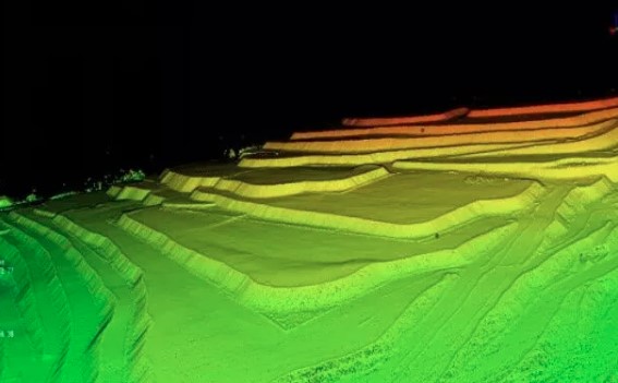
Unveiling the Technology
3D LIDAR, or Light Detection and Ranging, utilizes laser beams to measure distances with unparalleled accuracy. This cutting-edge technology enables us to capture precise three-dimensional representations of landscapes, structures, and assets. Unlike traditional surveying methods, 3D LIDAR offers a comprehensive and detailed view, leaving no room for ambiguity.
Aerial Mapping Elevated
In the realm of aerial mapping, the superiority of 3D LIDAR becomes evident. The technology facilitates sub-centimeter accuracy, allowing for meticulous mapping of terrains and structures. This level of precision is a game-changer, especially in industries where minute details matter, such as urban planning, environmental monitoring, and infrastructure development.
Empowering Drone Surveys for Optimal Asset Management
The Synergy of Drones and 3D LIDAR
Drones equipped with 3D LIDAR sensors take survey capabilities to unprecedented heights—literally. The combination of these two technologies results in surveys that are not only efficient but also remarkably accurate. From construction sites to agricultural fields, the marriage of drones and 3D LIDAR ensures a detailed and reliable assessment of assets.
Asset Management Redefined
Accurate data is the cornerstone of effective asset management. With 3D LIDAR laser scanning, businesses can now manage their assets with unprecedented precision. The technology allows for the creation of detailed digital twins, offering a virtual replica of physical assets. This not only streamlines maintenance processes but also enhances decision-making by providing a comprehensive overview.
Advantages Over Traditional Methods
Speed and Efficiency
Traditional surveying methods often consume significant time and resources. In contrast, 3D LIDAR laser scanning expedites the data collection process, enabling swift surveys without compromising accuracy. This efficiency not only saves costs but also allows for more frequent and up-to-date assessments.
Comprehensive Data Capture
Unlike 2D mapping or manual surveys, 3D LIDAR captures a wealth of data in a single scan. This comprehensive approach ensures that no detail is overlooked, providing a holistic view of the surveyed area. From terrain elevation to structural intricacies, the technology leaves no stone unturned.
Industries Transformed by 3D LIDAR Laser Scanning
Construction and Engineering
In the construction and engineering sectors, where precision is non-negotiable, 3D LIDAR laser scanning emerges as a transformative force. Accurate site assessments, structural analysis, and progress monitoring become seamless, contributing to the overall efficiency of projects.
Agriculture and Environmental Monitoring
Precision agriculture relies on accurate data for optimal decision-making. 3D LIDAR, when integrated with drones, facilitates detailed terrain analysis and crop monitoring. Similarly, in environmental monitoring, the technology aids in assessing ecological changes with unprecedented accuracy.
Conclusion: Navigating the Future with 3D LIDAR
In the evolving landscape of aerial mapping and drone surveys, the integration of 3D LIDAR laser scanning stands as a beacon of precision and efficiency. From elevating aerial mapping to redefining asset management, this technology is not just a tool but a transformative force. Embrace the future of precision—embrace 3D LIDAR.

No comments yet